This blog records various activities that my wife and I enjoy within one day's drive of our cabin on Lake Norfork in the Arkansas Ozarks. Of course, many of these activities take place right on the lake outside our window, so the earliest entry begins with a little factual information (culled from various web sites) about the lake and its history.
Showing posts with label Chesapeake Light Craft Northeaster Dory. Show all posts
Showing posts with label Chesapeake Light Craft Northeaster Dory. Show all posts
Some time ago I wrote about trying to sail my Northeaster Dory in high wind conditions. Last Saturday those conditions were met and I took the boat out on the water (after removing everything that might be lost in a capsize).
I'm confident I had the boat on a plane multiple times. I also shipped plenty of water and came as close to capsizing as I like. At times, indeed, the prevailing breeze was so strong that the boat was difficult to bring about, preferring to get stuck in irons.
Here are a couple of brief video clips:
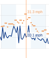
And here is a graph of wind speed during the period from noon to 3 PM when I was sailing:
All in all, it was perhaps a bit more wind than I could handle safely.
I can't explain what pushes me to wonder how fast my Northeaster Dory can sail. At 100 pounds hull weight and 15 feet waterline with 62 square feet of sail area, it's bit like a Windsurfer longboard, but I doubt it has the same top speed. The mast is located toward the front of the boat so in high wind conditions it's hard to get the bow far enough out of the water to initiate true planing on the aft part of the hull.
That said, the supposed "hull speed" for a 15-foot displacement hull is 6 mph, and I routinely sail the dory faster than that. I have had long(ish) reaches at 7 - 8 - 9 mph. And I always thought I could conceivably get the boat up on a plane.
I'm no longer sure I'd be able to tell whether or not the boat is on a plane, but today I sailed in conditions where the average wind speed was in the 10 - 15 mph range with brief gusts in the 20 - 25 mph range. I touched 13 mph in three gusts and had good runs at 9 mph. I thought the boat was manageable in the strongest gusts so it may be capable of extended runs at 13 mph or more. . . . But I'm not willing to be out on the water when the average wind speed is 20 and gust are 35. Even if I could manage the boat in those conditions, I'm not sure I could get the sail up safely or douse it without taking a drink.
13 mph is a nice number. I'll take it. . . . The following graphs provide raw data on boat speed and wind speed. Make of it what you will.
It was a windy three days. I mean it. And photos or weather graphs don't do it justice. Take that photo at the top. I guess you can tell there is a breeze on the water. But you can't tell that for five hours I had been hunkered down on a tiny scrap of an island, cowering behind the ragged remnant of a shrub with the dory pulled high on the rocks of the lee shore. You can't tell that at one point the gusts shrieked so hysterically that I staggered to the boat and deeply set the anchor into the battered beach, just in case my little ship started to sprout wings. Maybe a close-up can better convey the conditions.
I don't think that is adequate either so I'll have to stick to words, and I may as well start at the beginning.
I had made plans to set off on a 3-day adventure in the Susan Lee, my homemade CLC Northeaster Dory. I knew the forecast called for substantial wind and I relished the chance to sail, but soon after Sue dropped me off at Hand Cove Landing on October 16th, I began having doubts. I rowed the boat from the cove into the open lake and felt the caress of a gentle breeze. Up went the sail; it flapped idly. This was about 9 AM, and the weather charts begin to tell my tale.
Zoom in on that chart and you can see there is very little wind in downtown Mountain Home early that morning. And what wind there was ghosted from due south. Since my course was taking me eastward, the hilltops effectively blocked the breeze. It took me over an hour to get down to the dam where I could find unobstructed wind.
And wind there was! By 9:30 the gusts in Mountain Home were exceeding 15 mph. And if there is one thing this trip taught me, it's that lake wind is not the same as town wind. The lake is dominated by the river channels. The high bluffs block the wind in some places; channel and amplify it in others. As a road cyclist, I am used to feeling the wind on my face and think I can gauge its speed. The southern breeze, gusting to over 20 mph, gave me joyous, rollicking reaches all the way up the lake to the bridges (except for the drifting I did during the east-west passage at Tracy Bluff).
As the lake twists back on itself, there is a 3-mile wind slot from Tracy to Robinson Point and then another from Flint Knob to Bidwell Point. Never in my fifty-plus years of sailing have I enjoyed such long reaches before a screeching wind. The weather chart shows gusts in the 25 mph range, but I'd put them over 30 mph in the channels. As I swooped down on the first of the bridges, I began to feel jittery -- nervous about safely navigating between its concrete legs. Yes, they are spaced widely. But sailing on a broad reach meant that I would angle through them, and the following seas were steepening as I scooted along. I've read about broaching, but never experienced it. These conditions made me start to understand. As each big wave raised the stern of the dory, it pushed me into the wind. I'd then have a few precious seconds to wrestle the tiller and get the boat back on course before the next wave. Steering between those pilings made me feel like a drunk exiting a bar through a narrow doorway.
Once I had safely threaded the pilings of the highway 412 bridge, I was confident I could manage those of the 101 bridge. Then it was smooth sailing with a bit of shelter for the 3-mile stretch past Teal Point. A bend to the west left me sailing in parts of lake that were completely new to me.
At some rare places on Norfork there are a few homes close to the water on land that the Corps of Engineers couldn't (or didn't) condemn through its acquisitive power of Eminent Domain, but only Mallard Point has a large luxury community where each homeowner owns a private boat dock in front of his house and a private launch ramp into the lake. What an untold tale of crony capitalism in the FDR's day!
Partial panorama of Mallard Point homes
Does that home have an indoor tennis court or an airplane hanger?
The wind picked up again as I steered northeast past Cranfield and died away to a drifter in the hard bends around Indian Head. At this point I had been sailing all day without any break at all, gobbling gorp and sipping water when the wind allowed. I'd gone about 30 miles in 7 hours. Once again I was in a north-south channel passing Red Bank when the fading light of the sinking sun illuminated a set of ruins off to starboard.
The ruins of Red Bank
I wish I knew more about the history of this old house. It's obvious that it was built from local rocks and it must have stood there before construction of the dam began in 1941. But I have so far been able to find no additional information about it. It stands in romantic and mysterious isolation on the edge of the water.
The strong wind in the channel made camping at Red Bank impossible, but the lake soon made another hard bend and I was able to find a protected anchorage not far from Calamity Beach. I pulled ashore on a sandy beach and cooked my dinner while a majestic bald eagle looked on from atop a tree not a hundred yards away. After doing my dishes and replenishing my supply of filtered water, I anchored well offshore and began reconfiguring the dory for the night. The series of pictures below shows my PCV cot and foam pad -- first as stored for sailing and then as assembled. With an air mattress and a sleeping bag the dory becomes a remarkably comfortable little yacht.
Cot frame and foam pad secured for sailing
PVC cot pieces
Frame assembled
Accordion-fold foam mattress pad
It's rather reassuring to be anchored well offshore when the coyotes begin howling in the middle of the night. The light breeze and the gentle lapping of the waves against the hull are a kind of lullaby. I watched the stars come out and the moon arise. Then I awakened well before dawn, fully rested.
There was no point in lying longer abed, especially since I knew that the forecast was for even stronger southerly winds. I was giving myself two days to beat back upwind -- a slow grind -- but rowing during the predawn hours should be faster than sailing.
It was delightful being alone on the lake. The moon -- only two days past full -- gave me plenty of light. The only problem was the wind, which was still blowing at a substantial 10 mph in the channel past Red Bank. But I wasn't dim enough to attempt raising sail in the dark so I slogged on until it grew light. Almost as soon as I was finally able to raise my sail, I round a corner and the wind evaporated. I drifted from puff to puff, too lazy and content to want to row. Somewhere near Seward Point, I was back in the wind again -- wind in my face that was rapidly growing in strength. Here is the weather chart for October 17th, a day in which Aeolus went wild.
Note that there are steady gusts in the 15 mph range all night long (good thing I was anchored in a little bay at night), and note that by 10 AM the gusts are ranging from 25 - 30. It was slow work beating into that wind, but a fun challenge for both the skipper and the boat. By 11 AM I had rounded Chapin Point and was headed toward Cranfield. There the southerly wind loosed its full force in the channel. It was no longer the town wind recorded on the weather chart, but a raging beast let off leash. If I had to guess, I'd say the strongest gusts were in the 30 - 40 range, and I decided to seek shelter. I dropped sail in the lee of a little island just across from Cranfield and found the spot I described in the first paragraph of this post. Here it is on Google Maps. The whole island is only 500 feet long and rises only a couple of feet above the water. The three largest dark spots are Willow trees. The small dark spots are individual shrubs, and my shelter shrub was one of the larger ones on the northeast point of the island.
A sunny, warm afternoon on a secluded beach reading a Kindle book, cooking lunch (and dinner), and taking a chilly swim -- surely that's no one's idea of suffering, especially since I still had three beers in the cooler to enjoy with dinner. But lounging on the beach was not going to get me home. The wind had started to drop a little by about 5 PM. A half-hour after that I was under sail, trying to make my way as far upwind as I could before sundown.
Just after sunset I was able to drop sail and make my way under oars into the protected harborage behind Teal Point. The routine of dropping anchor and setting up my cot was now quickly accomplished, and I had another restful night under the stars (though somewhat annoyed by the traffic noise from highway 412 up the hill).
Again, I was up before dawn and under oars. I snapped this photo as I left the Teal Point homes in my wake.
My final day of sailing wasn't quite as windy, but the conditions were still challenging.
Note the wind gusting to 20 mph most of the night, then dropping in the morning (causing me to man the oars as I left harbor), and gradually building back to the 20 - 25 range from mid-morning to early afternoon. Here is a little video I shot while sailing the dory in conditions safe enough for me to hold my phone with one hand and sail with the other. The great fun for me during this day of sailing is that, as the wind rose, I learned I could sit on the windward rail and hike out, almost the way I had done when crewing on my father's Thistle as a kid. My next modification on the dory will be to add a hiking strap!
Sometime just after the noon whistle, I was able to make a final tack and head up the arm of the lake toward home. I glided back into Hand Cove before 2 PM with the wind almost dead astern. I was tired, a bit sun-burned, and a little weather-beaten. But genuinely happy.
This has been a perfect year on Lake Norfork. The winter was mild. Spring came relatively early. Rainfall has been frequent enough to avoid prolonged drought, and despite occasional bouts of torrential rain, there has been no major flooding in the streams and rivers; hence, the lake level has been quite stable. On the whole the summer has been fairly mild with no episodes of 100+ degree heat.
With these conditions it is no surprise that the fall shows signs of being spectacular. Now that the schools are again in operation, we have the lake to ourselves just at the time when the fall wildflowers are reaching their peak.
Today, Sue and I put the dory in and rowed out to Sand Island, one of three areas near Hand Cove and Jordan Landing with white sand beaches reminiscent of those on the Gulf Coast.
Tall Thoroughwort dominates the acres of wildflowers. . . . And I do mean "tall"! On our property the same plant grows to a height of maybe two or three feet. On the island there were specimens nearing six feet tall with stalks more like the trunks of saplings than seasonal flowers.
The Tall Thoroughwort was, of course, playing host to quite a large variety of interesting insects.
Common Buckeye Butterfly
Ailanthus Webworm Moth
Possibly a Byssus Skipper
Differential Grasshopper
Unidentified Moth
Tiny Caterpillar
Unidentified Beetle
The most common butterfly of all flitted about so incessantly that I could never creep up on it for a macro portrait, but it was about the size and color of a Cloudless Sulphur. There were also lots of tinier sulphurs flitting about.
One of the handsomest butterflies I saw would not pose for a close-up, but could be seen from a distance. It looked like a very dark Buckeye.
If you look past the Tall Thoroughwort, there was quite a lot of other interesting plant life along the beach. There were some tiny bluets that I didn't bother to photograph. In addition there was Small Morning Glory. But the prettiest flower was without doubt Bluecurls.
Bluecurls, Trichostema dichotomum
But Partridge Pea is a showier flower, especially on this beach where it grew into large and healthy bushes.
Partridge Pea, Chamaecrista fasiculata
While we are on the pea family, there was also plenty of Hairy Milk Pea, Galctia volubilis.
Finally, there were some plants that I have not yet identified. If you recognize the images on this "Most Wanted List," please drop me a line.
Fast sailing in the dory -- but Scott was replaced by backpacks for camping!
Yesterday afternoon I returned from my first extended cruise in the Northeaster Dory. I planned on staying out for three days and I packed generously, given the huge hauling capacity of the dory. I had two medium-sized backpacks, several bottles of water, a comfy folding chair, and a six-pack of beer. The dory swallowed all of that and begged for more, but I kept her on a fairly modest diet.
I set sail from Hand Cove at 10:30 on Thursday morning. The forecast was for moderate winds (10 mph) from the north-north-west. The forecast was wrong. Although the average speed of the wind was 9.4 mph over the 24-hour period, winds tend to ramp up in the middle part of the day, and while I was on the water, steady winds were in the 20 mph range with the peak gusts nearing 30. In truth it was frightening, especially since I was having to beat upwind for the whole day. For the first time, the dory threw occasional sheets of spray at me over the bow and briefly buried the lee rail in the water. I was continually "pinching" into the wind to keep control, and during the fiercest gusts I had to luff the sail. At those times the dory shook like a wet dog. The real trick was to avoid being forced down on a lee shore and then being unable to come about without going into irons. Somehow I managed it safely. During about five hours of sailing, I crawled more than 12 miles up the lake. But with all the beating back and forth, the actual distance covered by the boat had to be at least 25 miles.
The general route of my excursion
I was a weary man when I began to set up camp in second protected cove just south of the bridge.
Evening shadows at first day's campsite
One attraction of camping on Thursday night is that I knew I'd have a great location for watching the Eta Aquarid meteor shower in the predawn sky. I certainly got to bed early enough , , , and the skies started out clear enough . . . but as the hours crept along, it got colder and colder. The thought of lounging under the night sky at 45 degrees began to lack appeal -- especially since the cold air was causing fog to settle over the water. I stayed in my mummy bag, cocooned in the Hennessey Hammock until the sun began rising.
Too cold to cook breakfast, I gobbled some gorp and slurped some Gatorade. Then I broke camp, packed up the dory, and by 7 am was off on the second day's adventure. First I rowed up to the bridge and explored the Henderson boat dock with its collection of enormous and expensive houseboats. (The most gargantuan of these was appropriately named "Options.") A slight breeze stirred the lake and I quickly put up the sail, but it was just a lie -- and I soon went back to rowing.
For fun I went across to take a close look at Robinson Point Bluff from the water.
Looking up at the Robinson Point Overlook
While I have hiked the Robinson Point trail many times, one thing I didn't know is that there is a natural shelter well to the right of the overlook that should be easily accessible from the trail. You can see it in the photo below, just where the Juniper tree has dangled over the edge of the bluff.
And well to the left of the overlook there is a series of fairly large cave openings. These would be accessible from the top for a properly roped-in adventurer.
Bluff with cave openings
Closer view of cave openings
On my hikes at Robinson Point I have often enjoyed the view of the big bluff line across the bay. By water I was able to explore this bluff more closely and was delighted by two fanciful limestone rock formations:
See if you can find the giant stone toad!
And now we have the Stone Giant's boot
Having enjoyed a bit of tourism, I settled in for steady rowing. By lunch I was half-way down the lake at the same spot where I had stopped for a rest and a swim the day before.
Lunch island
More steady rowing got me home by about 2:30. The lower part of the lake has huge, nicely-spaced homes along the top of Tracy Bluff.
Tracy Bluff homes
As Tracy Bluff slopes toward its point, there is an interesting 1/4 mile of limestone / dolostone that nature has cracked vertically and horizontally into perfect stones for building a castle wall.
Natural Stone Blocks
More Natural Stone Blocks
The two-day cruise was enough of an introduction to cruise camping. I found, to my surprise, that beating 25 miles upwind in daunting conditions was more physically exhausting than rowing 14 miles on a glassy lake. But the dory proved itself a worthy vessel and an agreeable companion.
Over the course of the past few days, as I have completed the Susan Lee, I have made some unusual -- even controversial -- decisions about the best way to apply varnish. I make no pretense to expertise, but even so I will conclude with a few comments about the rationale for the process I used.
Some Speculations about Applying Varnish
Several days of warm winter weather brought daily high temperatures just warm enough for applying varnish after using some incandescent shop lights beneath the boat to warm the hull. In part because of the brevity of this warm spell, I decided to apply each of my final finish coats "hot" -- i.e., before the smell of the drying paint had fully dissipated.
Most experts insist that you must sand between coats to give the varnish some "tooth" that it can latch onto. The premise seems to be that a smooth gloss finish gives the new coat of paint too little to grip. Sanding is used to create a three-dimensional surface to which the fresh varnish can attach itself. And this implies that the bond itself is a mechanical one instead of a chemical one.
Frankly, I'm skeptical by nature and I'm especially skeptical of this reasoning. If the roughness of the surface is essential, then it should be preferable to sand with rough sandpaper instead of smooth sandpaper -- 110 or 220 grit, instead of 320 or 400. Yet none of the experts makes such a distinction. None of them discourages sanding with 400 grit, yet such a fine sandpaper scarcely roughens a fully dry surface at all.
After much reflection, I have concluded that the bond between coats of paint is probably chemical rather than mechanical. I believe the reason for sanding dry paint before re-coating it is to remove some of the thin, hard, oxidized surface layer. Whenever I have wet-sanded between fully dry coats, I have noticed the strong smell of varnish in the rag with which I wiped the boat down -- and perhaps even some smell of varnish from the boat itself. Furthermore, anyone who has sanded off a blob of varnish knows that the surface of the blob can be very hard while the inside remains soft (and smelly) for weeks, months, or years. I think the same thing is at work in sanding between "fully dry" coats. Once the oxidized surface is removed, the solvents in the new paint can mix with the solvents now exposed in the older layer, and chemical bonding can take place.
Now consider a thin coat of high-gloss varnish. I can get six coats out of just a quart of varnish (and I must keep each coat thin to avoid drips). Most of the volume of that paint as it is applied is actually solvents that evaporate fairly rapidly. So, once dry, the layer of paint is very thin indeed. Thus, if I were to sand between coats, I would be quite likely to remove most (or all) of the varnish I just applied. But if the paint is not entirely dry between thin coats (i.e., it is still off-gassing the solvents), then the new paint will have a chance to form a chemical bond with the old, and sanding should be unnecessary. This is especially true if one "refreshes" the solvents by wiping down the hull with denatured alcohol just before applying the new varnish.
Only time will tell if I am correct in these speculations. But it is my boat, and the worst that can happen is that I have to sand it down and start over. I'll update this blog if my varnish starts to flake off in the next six months or so.
(Update 10/8/16) Having subjected the boat to an entire season of use, I am pleased to report that the varnish has held up extremely well. There are, of course, a few scratches and dings, but the boat may not even need a touch-up for next spring.
(Update 12/11/2019) I lightly sanded and re-varnished the interior last spring -- in part because I wanted to switch from a matte finish to high gloss. The exterior of the hull is still in very good condition after four seasons of use. No problems with the coats of varnish adhering to each other.
A Safe Method for Turning the Boat
Early in the building process, the Northeaster Dory is light enough for two reasonably strong men to lift and turn easily, but as the boat accumulates fiberglass, hardware, and paint, it becomes somewhat heavier. Ultimately I decided to use a rope harness to lift and turn the boat.
Here is a picture that shows the system in overview:
The red rope is 1/2" rescue line capable of lifting thousands of pounds. Obviously one does not need rope that strong, but it is what I had on hand. Any 3/8" line should work equally well. I threw an end over a beam in the garage and tied a bowline, with the working end danging down to support the boat.
A loop of 1/4" black line is created from a three or four foot chunk of line using double fishermen's bends. Here is a nice web page about tying that knot:
This loop of line is connected to the 3/8" working line with a Prussik.
The two loops of white line can be any strong webbing made into a loop with an overhand follow through bend (or water knot). Alternatively, one can use a double wrap of 1/4" line or a single wrap of 3/8" line. Again, that line is made into a loop using double fishermen's bends. As you can see from the close-ups, I used D-rings to connect the white lifting loop to the black Prussik loop.
It's still a two-man job to raise and turn the boat, but it doesn't take much strength and there is virtually no risk of dropping the boat. To raise it, one person lifts one end of the boat while the other (from a step stool) slides the Prussik up as high as possible. The same procedure is used to lift the other end. Once the boat is suspended from the D-rings, the sawhorses are moved out of the way, and the boat can be easily turned as the white rope slides through the D-rings. One should keep a good grip on the hull so that it doesn't spin too fast or too far.
Lowering the boat just reverses the process. Once person lifts the boat to remove the weight from the Prussik. The other person reaches up, gently loosens the Prussik, and slides the knot down to the desired position.
That's all there is to lifting and lowering the hull.
________________________________
After months of challenging and interesting work and one final flipping of the hull, I now have a beautiful and complete Chesapeake Light Craft Northeaster Dory. With an ever-so-slightly regretful sigh of relief, I now bring this construction journal to --
THE END
They call it a "tombstone transom"!
. . . A fitting terminal image